
Ship Procession or “Kappalottam” at Kuravilangad Church
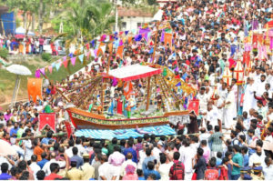
Every January, the ropes that tie her 40-foot-long body to the walls of the Kuravilangad Church in coastal Kerala are undone. Held up on the shoulders of fasting men, she moves with the throng around her outside the church, enacting the mythical memory of a storm. She has neither name nor owner, nor does she have traders or fishers aboard. She is, however, what ties one of the oldest religious minorities in the subcontinent to the Indian Ocean and its histories of maritime loss, dread, and faith. Without her, a tradition upheld by millions that dates back to the first century of the Common Era would be lost, even as she waits eleven months of the year to come alive for just one.![]() The Kappalottam is a three-day ritual procession (moonu noimbu) that takes place during what is called “sawmo d-ninwoyé” or the “Fast of the Ninevites” in the Eastern Orthodox liturgical calendar, three weeks prior to the Great Lent. What marks this period of ritual fasting and abstinence is the icon of the ship or kappal carried by fasters that is believed to represent (a) the ship on which the biblical prophet Jonah defied God’s command to sail to Nineveh, after which he fell overboard in a storm and (b) the first-century promise to the Virgin Mary (Muthiyamma) by the wealthy seafarers of Kadappoor to offer a replica of their ship to her if she saved them from drowning in a storm. Today, icons of the Virgin Mary and God the Father, as well as those of the prophet Jonah and the Kadappoor traders, stand atop the ship’s deck, replete with gold-plated crosses on every side. Given her essence as an icon, only those who claim a direct genealogical link to the Kadappoor community – and thereby claim elite caste and racial (Aryan) status – are traditionally authorized to carry and sail the kappal on their shoulders.
The Kappalottam is a three-day ritual procession (moonu noimbu) that takes place during what is called “sawmo d-ninwoyé” or the “Fast of the Ninevites” in the Eastern Orthodox liturgical calendar, three weeks prior to the Great Lent. What marks this period of ritual fasting and abstinence is the icon of the ship or kappal carried by fasters that is believed to represent (a) the ship on which the biblical prophet Jonah defied God’s command to sail to Nineveh, after which he fell overboard in a storm and (b) the first-century promise to the Virgin Mary (Muthiyamma) by the wealthy seafarers of Kadappoor to offer a replica of their ship to her if she saved them from drowning in a storm. Today, icons of the Virgin Mary and God the Father, as well as those of the prophet Jonah and the Kadappoor traders, stand atop the ship’s deck, replete with gold-plated crosses on every side. Given her essence as an icon, only those who claim a direct genealogical link to the Kadappoor community – and thereby claim elite caste and racial (Aryan) status – are traditionally authorized to carry and sail the kappal on their shoulders.![]() I take this indexical icon of the kappal as my object of inquiry to interrogate how ritual imaginings of the sea as a space of terror and divine rescue are, for the Eastern Orthodox in south India, mediated by the memory and materiality of a ship. While the origin stories of her iconicity rest on the image of a ship at sea in need of saving, she upends her history as an icon on land by now mimicking the waves of the sea on the shoulders of select men who raise and lower their arms in sync, standing in a contiguous circle around the ship. Her journey is no longer up to the fate of a storm; it is circumscribed within the ritual bounds of a calendar and the controlled wave-like motions of Kadappoor arms and shoulders that she “sails” on.
I take this indexical icon of the kappal as my object of inquiry to interrogate how ritual imaginings of the sea as a space of terror and divine rescue are, for the Eastern Orthodox in south India, mediated by the memory and materiality of a ship. While the origin stories of her iconicity rest on the image of a ship at sea in need of saving, she upends her history as an icon on land by now mimicking the waves of the sea on the shoulders of select men who raise and lower their arms in sync, standing in a contiguous circle around the ship. Her journey is no longer up to the fate of a storm; it is circumscribed within the ritual bounds of a calendar and the controlled wave-like motions of Kadappoor arms and shoulders that she “sails” on.![]() For a brief moment in 2018, however, the kappal found new meaning outside the space of procession and ritual. During the historic floods of Kerala that drowned hundreds in a matter of days, Christian fishers took up an historically inverted image of the kappal – that is, a ship that saves ¬– and turned their boats into rescue vessels, sailing flooded streets and pulling people up into them. Here, the symbolic import of the kappal crossed its ritual hold and incentivized a grassroots rescue mission. The floods and their capacity to drown indiscriminately also forced locals to grapple with the kappal’s gender, caste, and racial exclusions. In this liminal state of emergency, her invitation to carry and save was extended to all in need of what she stood for: divine safety from watery tempest.
For a brief moment in 2018, however, the kappal found new meaning outside the space of procession and ritual. During the historic floods of Kerala that drowned hundreds in a matter of days, Christian fishers took up an historically inverted image of the kappal – that is, a ship that saves ¬– and turned their boats into rescue vessels, sailing flooded streets and pulling people up into them. Here, the symbolic import of the kappal crossed its ritual hold and incentivized a grassroots rescue mission. The floods and their capacity to drown indiscriminately also forced locals to grapple with the kappal’s gender, caste, and racial exclusions. In this liminal state of emergency, her invitation to carry and save was extended to all in need of what she stood for: divine safety from watery tempest.