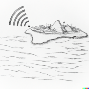
“I found something… it looks like an airplane wing.” This live, unfiltered announcement on Radio FreeDom in 2015 (also linked on the map at the northeast of Réunion Island) sent shockwaves across Réunion Island and the world. A caller, simply going about his day on the beach, made an extraordinary discovery: part of MH370, the infamous missing Malaysia Airlines flight, had washed ashore. Rather than notifying authorities, he called Radio FreeDom— an enormously popular local radio station where the people of Réunion can go live on air completely unfiltered. This moment exemplifies the core power of Radio FreeDom: in times of global relevance or local crisis, it becomes the stage on which Réunionese people shape the conversation. Radio FreeDom offers not just a broadcasting service but a way of being heard that is uniquely unmediated and communal, central to the island’s culture and identity. 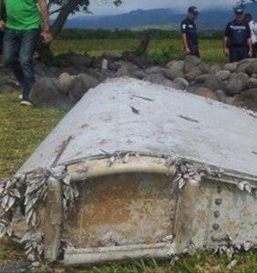 Likewise, when the Tresta Star ran aground on Réunion’s volcanic coastline during Cyclone Batsirai in 2022, it sparked frustration and anger among locals. One resident, disgusted by the shipwreck’s persistent presence, called Radio FreeDom to voice their outrage at the environmental blight tarnishing their island (recording linked to this map on the southeast corner of the island). The wreck had become a visual scar on a landscape treasured for its natural beauty, and it seemed as if no one was going to take the initiative to clean the call up. This call, broadcast in real time, once again demonstrates how the station acts as a conduit for public sentiment, bringing urgent issues to the forefront in ways that other channels—whether governmental or corporate—often cannot. Often, these issues relate to questions of (non)sovereignty. In Réunion, an overseas department of France and region of the European Union, the choice of how to clean up wreckage like the Tresta Star often lies with far away authorities. The consequences and public conversation, however, are highly local.
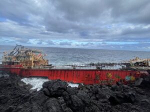
The recordings marked on this map near Réunion, of both the MH370 discovery and the Tresta Star debate, will live on the Réunion Sound Map, an (in progress) submap of the Oceans Map. These two pieces of audio serve as a pilot project for the sound map and are representative of Radio FreeDom’s function as an auditory archive of local life, capturing moments of both global significance and local strife. What makes these recordings so vital is not just their content but their medium: Radio FreeDom operates on the “free antenna” model, where callers speak live on air without any prior screening. This rawness, this unmediated flow of voices, is what makes Radio FreeDom a sonic reflection of life on Réunion—an island grappling with its identity, sovereignty, and place within the world.  However, these calls are not isolated incidents. These recordings are a hint to show the potential of how a Réunion Sound Map, built from Radio FreeDom’s rich but chaotic auditory archive, will offer far more than just a collection of crisis moments. It will allow users to explore a wide array of everyday interactions, from people seeking bureaucratic help when local infrastructure fails, to calls about lost pets, to deeply political dialogues on identity, nationalism, and regional solidarity. Radio FreeDom’s role is often that of a public utility where, when formal institutions fail to address local needs, the people turn to the airwaves to solve problems and voice concerns. The map will give users the opportunity to engage with this archive as a living record of how Réunionese people navigate both their immediate environment and their broader political and social contexts.
This is where the Oceans Map and the Réunion Sound Map take on deeper anthropological significance. The Oceans Lab project, co-created with Jatin Dua, is designed to address a significant issue in multimodal anthropology: sustainability. Many multimodal projects are exciting at launch but are quickly abandoned as scholars pivot to traditional academic publishing. This leads to digital anthropology projects becoming akin to shipwrecks—abandoned, deteriorating, or incomplete. Oceans Lab seeks to remedy this by creating a collaborative space where sub-projects like the Réunion Sound Map can live and grow, supported by multiple scholars and creators rather than being dependent on a single researcher’s time and resources. The wrecks of MH370 and the Tresta Star serve as metaphors for this challenge: much like these vessels washed ashore, many multimodal projects are launched with ambition but risk being left to corrode unless they are sustained by a broader community effort. ![]()
The inclusion of Radio FreeDom recordings on the Oceans Map serves as both a practical demonstration of what this platform can achieve and a theoretical response to the gaps in historical documentation, particularly in places like Réunion. Traditional archives, often dominated by written records in French, have marginalized the wealth of oral histories transmitted in Réunion Creole. Through the Réunion Sound Map, voices that have historically been excluded from public debates and academic research could be heard, preserved, and explored. This is especially crucial given that over 20% of Réunionese are illiterate, making oral forms of history and knowledge all the more important.
In this sense, the Oceans Lab project is not just a digital archive but a form of counter-mapping. It creates new ways of visualizing and organizing histories and experiences that have long been pushed to the margins. By offering dynamic filtering options—by topic, year, sound type, and more—the Réunion Sound Map will allow users to engage with the island’s history in ways that are accessible and participatory. This is not merely about representing past events; it is about empowering the people of Réunion to author their own historical narratives, navigating the intersections of sovereignty, freedom, and belonging. 
The broader Oceans Map seeks to capture voices from across the world in much the same way, particularly through its seafarer social media project, which aims to place academic voices alongside those of seafarers themselves. By integrating platforms like Radio FreeDom and global social media into a single map, the Oceans Lab creates a space where local and global narratives can coexist, offering new insights into how maritime and island communities engage with questions of identity, sovereignty, and human activity across the seas.
